Home / Academics / Programs / Outdoor & Environmental Science / Expedition Science
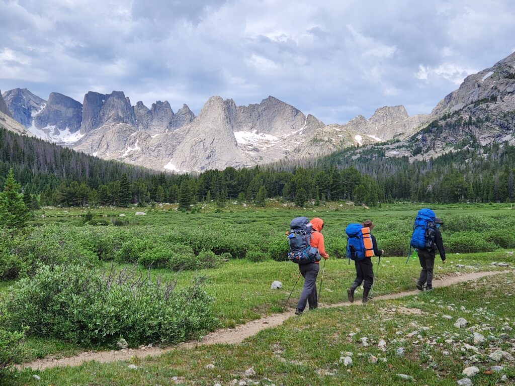
Expedition Science students study geography and environmental science where it happens—learning directly on glaciers, rivers, and landscapes across the Wind River Mountains.
Students develop expedition skills including leadership, navigation, risk management, and wilderness first aid while traveling through remote backcountry environments.
Students use mobile GIS tools during wilderness expeditions to support community and industry partners and solve real-world environmental problems.
Students work with agency and industry experts—such as the U.S. Forest Service—to collect field data and learn applied environmental research methods.
Outdoor education courses build hands-on skills like splitboarding, mountaineering, and backcountry travel in challenging environments
The CWC Alpine Science Institute, outside of Lander, Wyoming offers student housing, a campus farm, on-campus mountain bike park, and is minutes away from world-class rock climbing and fishing
The Expedition Science program integrates scientific research, field expeditions, and leadership development through experiential learning. Students build contemporary skills in environmental science, Geospatial Information Science and Technology (GIST), and outdoor leadership, applying these tools to real research questions in ecology, paleoecology, and environmental systems.
Students engage in extended field projects and internships, applying classroom and field research methods to contemporary environmental and geospatial problems. Research products are presented at conferences and shared with state and federal land management agencies. The program requires completion of at least one CWC or NOLS expedition.
Graduates are prepared for careers in natural resource management, environmental science, avalanche forecasting, outdoor education, glaciology, wildland firefighting, geospatial information science, and as National and State Park staff. This degree is designed for transfer to the University of Wyoming or other four-year institutions.
The student in this program will complete course work at the CWC Lander Center, CWC Alpine Science Institute, on public lands in the Wind River Mountains and Wind River Basin, and online.
What makes our program unique
Expedition Science at Central Wyoming College is rooted in place-based, hands-on learning at the Alpine Science Institute, where students live, study, and work at the doorstep of the Wind River Mountains, the Greater Yellowstone Ecosystem, and the Wind River Indian Reservation. This landscape becomes the classroom—students conduct real field science, integrate geospatial tools, and collaborate with land managers and community partners in one of the most ecologically and culturally significant regions in North America.

The EHS (Environmental Health and Safety) Environmental GIS Certificate I combines hands-on training in environmental field methods with classroom instruction in environmental, geospatial, and physical science. The student will exit the program with a firm foundation in the field of environmental science and Geospatial Information Systems. This certificate will prepare the student to enter the professional realm with improved technical skills to work in the following industries: energy and natural resources, state government, conservation non-profits, wildlife biology, wildland firefighting, avalanche forecasting, and federal agencies such as the United States Forest Service, Bureau of Land Management, and the National Parks. Courses from the EHS Environmental GIS certificate program can be applied towards completion of either an Associate of Science in Expedition Science and/or towards the AAS in EHS Environmental GIS.
The EHS (Environmental Health and Safety) Environmental GIS Certificate II combines hands-on training in scientific field methods, mapping, and outdoor skills. The student will exit the program with an introduction to the field of environmental science and Geographic Information Systems (GIS), so they can enter the professional realm with improved technical skills. Employment opportunities in this field are vast and include the energy industry, state government, conservation non-profits, wildlife biology, wildland firefighting, avalanche forecasting, and federal agencies such as the United States Forest Service, Bureau of Land Management, and the National Parks. Courses from the EHS Environmental GIS certificate program can be applied towards completion of either an Associate of Science in Expedition Science and/or towards the AAS in EHS- Environmental GIS.
The certificate I in Geospatial Information Science and Technology (GIST) emphasizes both the academic and technical skills required for the collection, analysis and manipulation of geospatial data. Geospatial data is information that identifies the geographic location and characteristics of natural or constructed features and boundaries on the earth. GIST refers to the study of the supporting science, hardware, software, and data acquisition skills required to collect and synthesize geospatial data. A geographic information system (GIS) is one form of geospatial technology; global positioning systems (GPS) and remote sensing (RS) are others. This certificate in GIST prepares students for employment as technicians in the fields of natural resources, government, public safety, mapping and utility companies, oil and gas, health and human service and consulting firms. Students will leave the program with both a theoretical background and hands-on skill set in the field of geospatial technologies
The certificate II in Geospatial Information Science and Technology (GIST) provides an introductory foundation in the academic and technical skills required for the collection, analysis and manipulation of geospatial data. Geospatial data is information that identifies the geographic location and characteristics of natural or constructed features and boundaries on the earth. GIST refers to the study of the supporting science, hardware, software, and data acquisition skills required to collect and synthesize geospatial data. A geographic information system (GIS) is one form of geospatial technology; global positioning systems (GPS) and remote sensing (RS) are others. This certificate prepares students for employment as technicians in the fields of natural resources, government, public safety, mapping and utility companies, oil and gas, health and human service and consulting firms. Students will leave the program with skills and background to complement virtually any profession that requires introductory level skills in the use and application of geospatial technologies.
Students in the Expedition Science program can receive credit, and professional work experience while participating in backcountry camping expeditions across Wyoming and around the world.
| Course Number | Course | Credits |
|---|---|---|
| BIOL 1080 | Intro to Environmental Science | 4 |
| ENR 2425 | Mountain Environments | 4 |
| OR | ||
| GEOG 1010 | Intro to Physical Geography | 4 |
| GEOG 1020 | Intro to Human Geography | 3 |
| GIST 1200 | Geospatial Foundations | 4 |
| HLED 2010 | Wilderness First Responder | 4 |
| MATH 1400 | College Algebra | 4 |
| OEAC 2020 | Mountaineering: | 1-5 |
| OR | ||
| OEAC 2030 | Wilderness Backpacking: | 1-5 |
| OR | ||
| OEAC 2031 | Combined Expeditions: | 1-5 |
| OEAC 2025 | Wilderness Navigation | 1 |
| ORTM 1000 | Foundations of Recreation & Tourism | 3 |
| ORTM 2410 | Outdoor Leadership | 3 |
The student may substitute HLED-2015 Wilderness EMT (9cr) in place of HLED-2010. This will add 5 Program Elective credits to the student’s total program.
Student must choose a minimum of ten (10) credits from the following courses:
| Course Number | Course | Credits |
|---|---|---|
| ANTH 2010 | Cultural Resources Field School | 3 |
| ATSC 2000 | Introduction to Meteorology | 4 |
| ATSC 2110 | Introduction to Climatology | 4 |
| BIOL 1010 | General Biology I | 4 |
| BIOL 2005 | Natural History of Yellowstone | 4 |
| CMAP 1200 | Computer Information Systems | 3 |
| CMAP 1765 | Spreadsheet Applications: | 3 |
| CPED 1000 | Co-Op Work Experience I: | 3 |
| OR | ||
| ORTM 2470 | Outdoor Education Practicum | 4 |
| EDUC 1055 | Introduction to Outdoor Education | 3 |
| ENR 2010 | Environmental Law | 3 |
| ENR 2150 | NAI Certified Interpretive Guide | 3 |
| ENR 2200 | Greater Yellowstone Ecosystem Naturalist | 4 |
| GEOG 2950 | Research In: | 3 |
| GIST 2000 | Professional GIST: | 1-6 |
| GIST 2110 | Techniques in Cartography | 4 |
| GIST 2135 | Applied GPS for GIS | 3 |
| GIST 2140 | Survey of Remote Sensing Applications | 4 |
| GIST 2310 | Intro to Geographic Information Systems | 4 |
| GIST 2395 | Capstone Project in Geographic Information Systems | 3 |
| GIST 2410 | Advanced Geographic Information Systems | 4 |
| GIST 4950 | Research in: | 1-6 |
| HLED 2010 | Wilderness First Responder | 4 |
| NAIS 2000 | Indians of the Wind River | 3 |
| NAIS 4340 | Natural Resource Management on Western Reservations | 3 |
| OEAC 1175 | Ice Climbing | 1 |
| OEAC 1258 | Skiing and Snowboarding | 1 |
| OEAC 1287 | Outdoor Rock Climbing | 1 |
| OEAC 1297 | Whitewater Rafting and Rescue | 1 |
| OEAC 1380 | Outdoor Multisport | 1-3 |
| OEAC 2058 | Backcountry Skiing and Snowboarding | 1 |
| STAT 2050 | Fundamentals of Statistics | 4 |
General Education requirements provide students a general knowledge to help them complete a degree at CWC.
| Writing Level I (WR1) | 3 credits |
| Writing Level II (WR2) | 3 credits |
| American & Wyoming Government (POLS 1000) | 3 credits |
| Student must complete six (6) credits of General Education courses distributed over two (2) different general education areas, ARTS/HUM/SOC. (SOC is in the program) | 3 credits |
| SOC | (in program) |
| LSCI | (in program) |
| MATH | (in program) |
| ORAL | 3 credits |
| UNST | 1 credits |
Darran Wells is passionate about all kinds of outdoor activities – hiking, climbing, caving, and skiing, but mountain biking is a sport he dedicates most of his free time to.

Jacki Klancher has been an educator for more than 20 years. Originally from Patricia, Alberta Canada, Klancher has been at CWC for more than 10 years as a professor and she was integral in launching the Interdisciplinary Climate Change Expedition. This undergraduate research program has allowed her to integrate the classroom component of the EHS Environmental GIST and Expedition Science programs with wilderness travel and adventure.

INSTRUCTOR OF GIS AND EXPEDITION SCIENCE
Mara grew up in Lander, Wyoming and loves finding ways to connect students to their local environments and communities. She teaches GIS, environmental science and geography, and she helps facilitate and teach summer backcountry research expeditions.

Professor Emeritus of Anthropology and History
Todd Guenther is passionate about anthropology and getting his students the field experience needed for the next level.
If you have an interest in expedition science, environmental science, geospatial information systems technology (GIST), or outdoor education we recommend you live in Lander, WY or in our student housing at the Alpine Science Institute at Central Wyoming College.

Outdoor Program Leadership
Take the next step in your outdoor leadership journey. This 8-semester program offers students an administrative perspective of the outdoor recreation service industry that includes learning, training, and assessment of leadership and program management skills. The program is especially appropriate for students wishing to: start their own outdoor-related small business, manage an outdoor recreation or education program, or build a career in leadership of parks, recreation, tourism, or natural resource management.